Category: Weather

  • Got a minute? Here’s the latest on Category 4 Hurricane Erin, and what you should know

    Snapshot: What’s Happening with Hurricane Erin

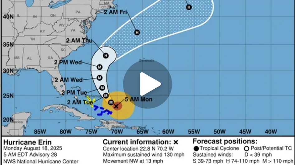
    Current Status: Hurricane Erin has re-intensified into a Category 4 storm. It now boasts sustained winds of roughly 130 mph (215 km/h). This follows a previous peak as a Category 5 with winds reaching 160 mph.

    Location & Movement: As of today, Erin sits about 105 miles north-northeast of Grand Turk Island, moving northwest at around 13 mph (20 km/h).

    Size & Impact Radius:

    Hurricane-force winds now extend about 60 miles from the center.

    Tropical-storm-force winds stretch out to 230 miles.

    The wind field has expanded dramatically, influencing seas hundreds of miles from the eye.

    Threats & Watches:

    Tropical Storm Warnings/Watching: In effect for Turks and Caicos, southeastern and central Bahamas.

    Evacuations & Alerts:

    Dare County, North Carolina declared emergencies and issued evacuation orders for Hatteras Island; concerns over highway closures due to wave overwash.

    Outer Banks and Bermuda remain on alert for hurricane-force winds and coastal flooding.


    ​ Why It Matters (Even Without Landfall)

    Though Erin is not expected to make direct landfall, it poses serious risks:
    1. Life-Threatening Surf & Rip Currents: Widespread hazardous surf is expected along the East Coast of the U.S., Bahamas, Bermuda, and Atlantic Canada over the next several days.
    2. Coastal Flooding & Beach Erosion: High waves—possibly 20–25 feet, with rogue waves over 30 feet near Bermuda—could inundate low-lying areas and damage shorelines.
    3. Island Impacts: The Caribbean, Puerto Rico, Virgin Islands, and Bahamas have already experienced heavy rain, flash flooding, landslides, power outages, and flight disruptions.
    4. Structural Expansion: Erin grew through an eyewall replacement cycle, slightly weakening it but significantly expanding its wind field—a scenario that spreads danger across a broader area.

    What You Can Do (If You’re in Impact Zones)

    Heed official warnings and evacuation orders, especially in vulnerable coastal communities.

    Avoid beaches and swimming areas—rip currents can be deadly even without storm landfall.

    Secure property and prepare for power outages, particularly in vulnerable island and coastal regions.

    Monitor updates from trusted sources like the National Hurricane Center and local emergency services.


    In Summary

    Key Point Detail

    Storm Strength Currently Category 4 (130 mph), peaked at Category 5 (160 mph)
    Threat Radius Large: hurricane-force winds ~60 mi; tropical-storm winds ~230 mi
    Areas at Risk Bahamas, Turks and Caicos, Outer Banks, Bermuda, East Coast, Canada
    Main Hazards Dangerous surf, rip currents, flooding, winds, island disruptions
    Current Movement Northwest at ~13 mph, expected to pass off U.S. East Coast midweek
  • U.S affected by heatwaves 2025

    Restored: The “Second Heatwave” of 2025 in the U.S.

    Early Wildfire: First Heat Event (May – june)

    In mid-May 2025,

    the U.S. experienced an unusually early-season heatwave, particularly intense in Texas and Minnesota. Del Rio reached 109 °F and San Antonio hit 102 °F, while International Falls, Minnesota, recorded 96 °F—marking historic daily highs.
    This heat wave already pushed spring temperatures higher than typical, indicating a trend toward earlier and more intense summer-like heat.

    The Second Heatwave (Summer: June–August)

    Underlying Conditions & Forecast

    NOAA projected above-average summer temperatures across nearly the entire U.S., with the West, Southwest, Gulf Coast, Florida, and Northeast expected to endure prolonged heat waves.

    The summer of 2025 is poised to be among the hottest on record, with NOAA giving it a 39% chance of being the second-warmest year in U.S. history, and a 99% chance of ranking within the top five.

    Heat Dome and Persistent High Heat

    A powerful heat dome formed over the U.S., initially impacting the Midwest and eastern regions, with temperatures surpassing 105 °F (40 °C) and overnight lows staying above 75 °F (24 °C).

    NOAA’s satellites observed this heat dome’s persistence, noting its spread across the Midwest, Ohio Valley, and up into the Northeast through late June.

    Scope & Climate Attribution

    From July 21 to 25, a particularly relentless surge of heat and humidity gripped large swaths of the country—affecting nearly 160 million people, or nearly half the U.S. population. Climate change made this extreme heat at least three times more likely.

    Impacts and Responses

    Health & Infrastructure Threats

    Across the central and eastern U.S., cities like Chicago, Kansas City, St. Louis, Detroit, Cincinnati, Pittsburgh, Washington D.C., New York City, and more were under extreme heat alerts, with heat indices climbing to 115 °F (46 °C).

    In New York, the governor declared a state of emergency as the heatwave threatened to shatter records dating back 125 years.

    The heat strained power systems—Con Edison in New York City reduced voltage by 8%, and other parts of the East Coast and Midwest reported widespread outages.

    Over 130 million Americans across 11 states faced extreme heat, leading to warnings about rising electricity bills, especially for New Yorkers.

    Climate Trends & System Stress

    Heat-related deaths and illnesses surged. Texas saw early records broken, highlighting an earlier and intensified onset of summer heat that stresses public health systems.

    Infrastructure and emergency response capacities were stretched thin due to staffing and funding reductions at federal agencies amid growing demands for heat resilience.


    Summary: 2025 U.S. Second Heatwave at a Glance

    Phase Dates/Period Highlights

    First Heatwave Mid-May Record-breaking temperatures in Texas and Minnesota
    Major Summer Heat June–July Nationwide heat dome, extended heat, high minimum temps
    Climax Period July 21–25 Heat affecting 160M people; climate made it ~3× more likely
    Impacts & Responses June–July States of emergency; power strain; energy price hikes


    What’s Next?

    Public Health Efforts: Authorities should prioritize cooling centers, hydration campaigns, and outreach to vulnerable populations.

    Infrastructure Upgrades: Strengthening power grids and investing in resilient urban design is critical.

    Policy & Climate Action: This year’s events underscore the urgent need for climate adaptation strategies and strong federal support.